

K-12 Emergency Planning Maps: Floor plans, area maps, evacuation routes, and responder-ready building views in one updateable workflow
Facilities Resource
District teams researching emergency planning tools are usually not asking whether they need a PDF on file. They are asking whether one system can help them maintain accurate floor plans, area maps, evacuation routes, and critical asset locations without restarting the work every time a building changes.

What emergency planning includes
Emergency planning in a K-12 district is not just a compliance document. It is the ongoing process of keeping floor plans, campus maps, room labels, entrances, exits, shutoffs, life-safety equipment, evacuation routes, and responder-facing building information clear, current, and easy to share.
The practical question is not whether a district can produce an emergency map once. It is whether staff can update that map quickly, control who sees what, and maintain a usable record for emergency responders, district leaders, and facilities teams over time.
At a glance
- District buyers usually evaluate this topic across five decision points: floor plan accuracy, campus and area maps, emergency asset visibility, evacuation route updates, and controlled sharing.
- Emergency maps become more useful when they are easy to update after building changes.
- Asset visibility matters because responders need clear locations for shutoffs, panels, AEDs, extinguishers, and related life-safety equipment.
- Area maps matter because districts need more than interior floor plans. They also need entrances, exits, traffic flow, assembly areas, and site context.
- The strongest workflows support both printable output and secure live access.
The Core Answer: What emergency planning actually means in a K-12 district
District teams researching emergency planning tools are usually not asking whether they need a PDF on file. They are asking whether one system can help them maintain accurate floor plans, area maps, evacuation routes, and critical asset locations without restarting the work every time a building changes.
Emergency planning in K-12 spans several document types that must stay in sync. Interior floor plans show room layouts, labeled spaces, entrances, exits, windows, doors, and life-safety equipment. Area maps show the campus at a broader scale — roads, traffic patterns, buildings, outbuildings, playgrounds, sports fields, assembly areas, evacuation zones, and reunification points. Evacuation route documentation captures how people move through and out of buildings under different scenarios.
Each drawing type creates its own update demands. A room renumbering affects floor plans. A site renovation may affect area maps and evacuation routes simultaneously. If plans live in separate static files, every change means restarting or manually redlining documents that may already be out of date.
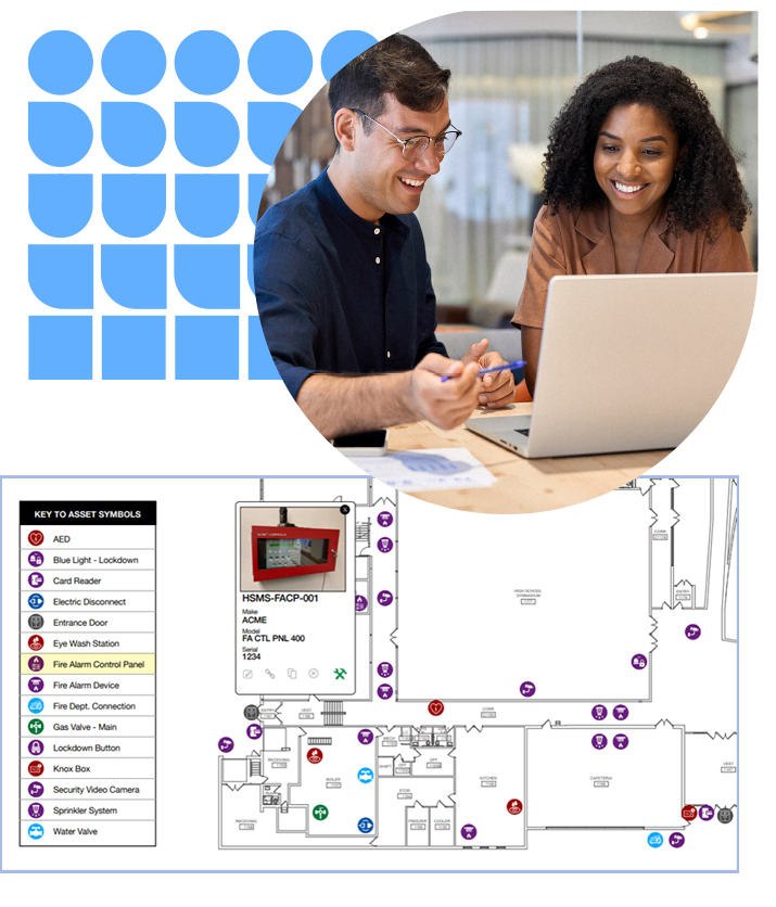
Emergency asset visibility adds another layer. Responders arriving at a building need to locate shutoffs, alarm panels, sprinkler controls, Knox Boxes, AEDs, fire extinguishers, and cameras quickly. That information is most useful when it is mapped directly onto the floor plan — not documented separately — and when filtered views can isolate the relevant assets for a specific response scenario without cluttering the overall map.
Access and distribution are the final practical question. Some districts primarily need printable PDFs for binders and compliance documentation. Others need secure live access so that selected staff, contractors, or responding agencies can see current plans without waiting for a new file to be distributed. The right answer depends on district policy, response coordination requirements, and which audiences need access under what conditions.
See how Facilities Drawings supports emergency planning
If your team is moving from topic research to product evaluation, start with Facilities Drawings. That page shows how Follett Software helps districts maintain floor-plan-based building records, filter views, annotate maps, and keep emergency information current.
View Facilities DrawingsHow district teams actually use emergency planning maps
The Operational Problem
In practice, districts use emergency planning tools to keep critical building information current across both daily operations and high-stakes situations. A facilities leader may need to update a campus map after site changes. A school may need evacuation maps adjusted for a new room layout. A district may need to document shutoffs, alarm panels, Knox Boxes, AEDs, cameras, or reunification areas in ways that are easier for responders to understand quickly.
That is why buyers researching this topic tend to ask more detailed questions than whether a drawing can be printed. They want to know whether the map can show required emergency assets clearly, whether floor plans and site maps can be updated without starting over, whether filtered emergency views can be generated for specific use cases, whether evacuation information can stay readable, and whether local agencies can receive secure access when needed.
What this looks like in real district workflows

One record, every exit
A district can maintain floor plans with labeled rooms, entrances, exits, windows, doors, and emergency-related assets in one visual record.

Map the full campus
A facilities team can create campus and area maps that show roads, traffic flow, buildings, playgrounds, sports fields, assembly areas, evacuation areas, and reunification points.

Mark life-safety assets
A district can mark emergency shutoffs, fire alarm panels, sprinkler controls, Knox Boxes, AEDs, fire extinguishers, cameras, and other life-safety assets directly on the map.

Update routes, not redlines
Staff can update evacuation routes, notes, symbols, and map callouts as buildings change instead of redlining paper copies by hand.

Export or share securely
Districts can export PDFs for required plan documentation and also provide secure, permission-based live access to selected users when that is the better fit.
The five operational decisions district teams work through
What buyers are really deciding on
District buyers usually narrow this topic down to a small set of operational decisions. These are the questions that come up in facilities planning meetings, safety audits, and tool evaluations — not just in a vendor demo.

How current do emergency floor plans need to stay?
The issue is rarely whether a district has some version of a plan. The real question is whether updates can be made quickly enough to keep pace with building changes, renovations, room renumbering, or equipment moves. Districts with frequent changes need a workflow that supports fast, accurate updates — not a one-time document production process.
What information needs to appear on the map?
Some districts only need room and exit visibility. Others need utility shutoffs, alarm panels, security devices, reunification areas, traffic flow, and other response-critical details shown clearly. Deciding what must appear — and what should be filterable rather than always visible — shapes the entire map design and update workflow.
Should emergency assets live in filterable views?
As maps become more detailed, filtered views matter more. Districts need to decide whether staff and responders should be able to see only the emergency-related systems and assets relevant to the task at hand. An asset-level filter that isolates AEDs or shutoffs is more useful under pressure than a single dense map showing every mapped system at once.
How should evacuation routes and campus maps be maintained?
Emergency planning often includes more than one drawing type. Buyers need to decide whether they want one workflow for interior floor plans, site-level area maps, and route-related updates — or whether managing those materials in separate files and tools is acceptable given their district’s capacity and update frequency.
Who needs access and in what format?
Some districts primarily need printable PDFs for emergency binders and compliance documentation. Others also need secure live access for selected staff, contractors, or agencies. The right answer depends on district policy, response coordination needs, and which audiences need to view current plans under what conditions.
See how Facilities Drawings supports emergency planning
If your team is moving from topic research to product evaluation, start with Facilities Drawings. That page shows how Follett Software helps districts maintain floor-plan-based building records, filter views, annotate maps, and keep emergency information current.
View Facilities DrawingsFour steps before selecting an emergency planning tool
How to evaluate this workflow
These are the evaluation steps facilities teams and safety coordinators should work through before comparing vendors. Start with what your district must maintain, then test the workflow against a real update scenario.

Start with the plan types your district must maintain today
Floor plans, area maps, and evacuation-route views are related but create different update demands. Identify which types you are legally required to maintain and at what review frequency before evaluating any tool. Some districts have state-specific emergency planning mandates that specify the content and format required.

Audit where your plans break down after building changes
Review how changes are currently made after renovations, room renumbering, or equipment moves. That is where static files usually fail. If your current process involves redlining paper copies or hunting through file folders for the last version, that gap is your evaluation starting point, not a product feature list.

Decide which emergency assets need to appear on the map
Resist the impulse to map every system onto your emergency floor plans. Decide which assets — shutoffs, AEDs, alarm panels, Knox Boxes are truly response-critical for your district’s use cases. Use filterable views for assets that only some audiences need. The goal is a map that is usable under pressure, not comprehensive at the cost of clarity.

Test the update workflow, not just the output
Ask vendors to walk through how a team updates, exports, and reissues a plan after a real building change. That is a more useful evaluation exercise than a one-time demo of a static map. Specifically: how long does it take, who can do it without training, and what happens to previously distributed versions when a plan changes?
See how Facilities Drawings supports emergency planning
If your team is moving from topic research to product evaluation, start with Facilities Drawings. That page shows how Follett Software helps districts maintain floor-plan-based building records, filter views, annotate maps, and keep emergency information current.
View Facilities DrawingsFAQ's
-
The stronger workflows make the drawing easier to update as rooms change, equipment moves, or site conditions shift. That matters more than having one static PDF if the district needs plans that stay accurate over time.
-
That depends on district requirements, but many teams need labeled spaces, entrances, exits, shutoffs, alarm-related assets, safety equipment, and campus context such as roads, parking, evacuation areas, and reunification points.
-
They help districts show only the assets and systems needed for a particular emergency-planning use case. That makes the map easier to read and easier to use under pressure.
-
They usually need a workflow where route-related annotations, symbols, and map edits can be updated without rebuilding the underlying drawing from scratch. The easier those updates are, the more likely the district is to keep plans current.
-
Often, yes. Many districts still need printable output for formal documentation, but secure live access can be useful when selected staff or agencies need up-to-date information without waiting for a new file to be distributed.
-
Emergency planning becomes a more serious district workflow when the challenge is no longer just producing a map once. The real work is keeping floor plans, area maps, evacuation information, and response-critical asset details current as buildings and campuses change.
Summary
Emergency planning becomes a more serious district workflow when the challenge is no longer just producing a map once. The real work is keeping floor plans, area maps, evacuation information, and response-critical asset details current as buildings and campuses change, and making sure that information is accessible to the right people, in the right format, when it is actually needed.
For districts researching that problem, the next step is to review how Facilities Drawings handles it in practice.